
When you rent a boat, especially a sailing yacht, it is not always equipped with a reliable navigation system. Fortunately, you no longer need a sextant, as was the case at the beginning of the 20th century. Nowadays, anyone can become an expert with the help of navigation apps. As the number of apps can be a little overwhelming, we have tested some of them especially for you and compiled a list of the best apps!
1. Navionics – Boating Marine & Lakes
![]()
The Navionics app is a guarantee of reliability for many sailors and one of the most popular apps for navigation on a sailing boat. With the latest update, connectivity on the water has been improved. This makes it easier to share your live location with friends and family. You can then export your route in GPX format to share your achievements with others.
The real strength of the app lies in the large community that constantly updates and improves Navionics' maps and information. In addition to the extensive functions, the app is characterized by its user-friendliness: the focus is always on the user.
Navionics offers several map layers that can be adapted to your own needs and personal preferences. A major advantage is that you can edit your own maps and adapt them to your needs, for example sonar maps. This gives you access to the HD bathymetry map, which provides a detailed view of the bottom of lakes and shallow waters. Ideal for finding the best fishing spot and knowing the exact depths. All the functions of this navigation app are extensive and work very well. Functions such as a WLAN AIS receiver, weather and tide forecasts and much more round off your sailing experience.

2. savvy navvy – ship navigation

The sailing tips in one place. The app displays chart, tide, weather, route, marina and anchorage information at the touch of a button on any device. Savvy Navvy is designed for a clear user interface and ease of use, making navigation simpler and more accessible.
For example, you can use great features such as active GPS tracking to see exactly where you are and which facilities are in your vicinity. The special thing about this app is that it maps the entire route for you in just a few seconds, using high-quality data from hydrographic stations around the world. It adapts your route en route to the different tides, your departure times, the weather, wind forces/directions and even boat data.
The ability to automatically adjust your route planning to the wind direction is a fantastic feature for sailors. Apart from Orca, no other app is able to automatically adjust the route to the conditions you encounter while sailing. This makes the app a very reliable navigation device to accompany you on your sailing trip. If you are not yet completely convinced, you can also test the app free of charge for 14 days.
3. C-MAP – Marine Charts. GPS navigation for boats
![]()
C-MAP is an excellent app for navigating the sea with your sailboat. It offers high quality nautical charts, supported by data from official hydrographic stations, which are constantly updated to ensure the clearest charts. A major advantage is that these charts cover both inland waterways and coastal waters worldwide. This means that you can access and use your charts anywhere to reach your destination.
As with the other navigation apps, you can save routes, waypoints and tracks and view the weather forecast, including waves and tides. The app also displays useful information about (yacht) ports, beaches and even some shops. What sets this app apart from other apps is its simple design. This makes it easy to use and makes navigation a pleasant experience without much effort, even for someone who has never sailed before.
To download the content and use it offline, you need to purchase the upgrade to the premium version. This version can be tested free of charge for 14 days.
4. iNavX Marine chart plotter
![]()
The iNavX app is an advanced chart plotter for recreational and professional sailors. Firstly, it is the only one of the five apps mentioned that combines 8 chart providers in one app, similar to Navionics. This gives you the freedom to buy the map that suits your needs. The app is also able to use your cell phone's GPS to determine your position in real time. Become an expert with iNavX by planning your own route, setting and saving waypoints and switching between levels without losing your waypoints.
But that's not all; mastering more advanced features may take a little longer. For example, there is also an anchor alarm that prevents you from drifting off at night. Weather and tide forecasts and an automatic information system alarm are also included. With this system, the app can provide useful information about your engine, speed, depth and wind by connecting to the boat's nautical instruments. All in all, a very smart navigation app that uses multiple chart providers so you always have a map for the area you want to sail in. The only drawback we noticed is that the Android app doesn't work as well as the Apple version. For an optimal experience, we therefore recommend using the app on an iPad/iPhone.
5. Orca – The marine CoPilot
Orca provides you with weather and tide forecasts used by the proactive “Co-Pilot”, which guides you through your sailing route with accurate nautical charts. In addition, the intelligent system also learns from your boat and displays fuel capacity, battery status, engine and other boat details. Good to know is that this app is only available in combination with one of their hardware products (Orca Core or full Orca system). In our opinion, this app has the potential to replace traditional chart plotters.
A fantastic solution for lost connections at sea is the Orca Core, which creates a wireless extension by connecting to your NMEA 2000 network on board. This small device has an integrated GPS and compass. It can also connect to your boat's sensors and engine data to determine your ideal cruising speed, for example. The Orca Core will enrich your navigation experience on all your devices.
As you probably know, the sea can be pretty rough sometimes. Orca had this in mind when they developed their waterproof tablet. It's a screen that attaches to your boat and is designed to withstand all weather conditions, especially at sea. However, that doesn't mean you can't use your own tablet to navigate with Orca.
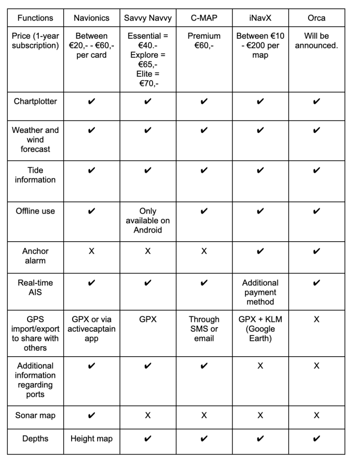
Comparison of the app's functions
Summary
All of these navigation apps have their own special features that make them unique. Some are more comprehensive than others. Therefore, you should ask yourself how many of these features you will actually use; because all the apps mentioned in this list are of excellent quality, but the prices vary. It should be noted that not all digital nautical charts can fully replace paper nautical charts for navigation. As a sailor, you are responsible for having accurate and up-to-date nautical charts.
We all love sailing and exploring new areas. However, this requires some skills. Let the new technology enhance and facilitate your sailing vacation so you can relax. For more information, you can contact the Tubber team at any time.